Relief Editing
Now that the basic landscape elements have been created, it is time to change the map relief. Using the editor tools, you can create steep mountains or slanting hills, small ravines or fathomless pits.
The  button activates the altitude changing mode. Point your cursor at a map area you want to change the height of. Press the left mouse button to raise an area or the right button to lower it. Holding down a mouse button and smoothly moving the cursor across the scenery creates a mountain ridge or a ravine. On the panel in the right part of the screen is a scrollbar you can use to change the size of the brush.
button activates the altitude changing mode. Point your cursor at a map area you want to change the height of. Press the left mouse button to raise an area or the right button to lower it. Holding down a mouse button and smoothly moving the cursor across the scenery creates a mountain ridge or a ravine. On the panel in the right part of the screen is a scrollbar you can use to change the size of the brush. Another altitude changing mode can be activated by clicking the  button. The difference between this and the previous mode is that this one creates an elevation with a flat summit.
button. The difference between this and the previous mode is that this one creates an elevation with a flat summit. The  button activates the area levelling mode. Point your mouse cursor at the map area you want to level, and press the left mouse button. The whole area under your brush will be transformed into a plain equalling the central point in height. In this mode, you can use the right mouse button to add random irregularities to the landscape. Press the right mouse button to see the area of the map under your brush gradually be covered by small elevations and slopes.
button activates the area levelling mode. Point your mouse cursor at the map area you want to level, and press the left mouse button. The whole area under your brush will be transformed into a plain equalling the central point in height. In this mode, you can use the right mouse button to add random irregularities to the landscape. Press the right mouse button to see the area of the map under your brush gradually be covered by small elevations and slopes. The smoothing mode turned on using the  button gives the area a more natural appearance. Smoothing allows you to get rid of sharp angles and lessen slopes that are too steep. Point your mouse cursor at an area you want to smooth and left-click. The area under the brush is gradually smoothed. Pressing the right button in this mode creates ledges on mountain slopes.
button gives the area a more natural appearance. Smoothing allows you to get rid of sharp angles and lessen slopes that are too steep. Point your mouse cursor at an area you want to smooth and left-click. The area under the brush is gradually smoothed. Pressing the right button in this mode creates ledges on mountain slopes. The  button activates the relief area editing mode. Left-click on the edge of the area you want to change. A yellow line will expand as you move the mouse cursor away form the place where you clicked. By left-clicking you can encircle the area you want to select with the yellow line. To end the selection of a map area, close the polygon or click with the right mouse button. An action selection menu will appear on the screen: Cubic - Create a slanting hill in the area within the yellow line. You can specify its height in the lower menu string. Squad - Create a steep hill in the area within the yellow line. You can specify its height in the lower menu string. Smooth - Smoothen the area within the yellow line. Road1, Road2, Road3 - Draw one of three types of road along the yellow line.
button activates the relief area editing mode. Left-click on the edge of the area you want to change. A yellow line will expand as you move the mouse cursor away form the place where you clicked. By left-clicking you can encircle the area you want to select with the yellow line. To end the selection of a map area, close the polygon or click with the right mouse button. An action selection menu will appear on the screen: Cubic - Create a slanting hill in the area within the yellow line. You can specify its height in the lower menu string. Squad - Create a steep hill in the area within the yellow line. You can specify its height in the lower menu string. Smooth - Smoothen the area within the yellow line. Road1, Road2, Road3 - Draw one of three types of road along the yellow line. 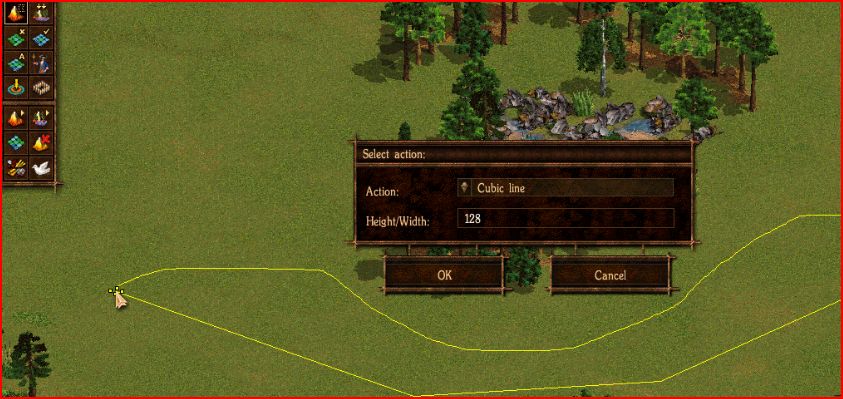
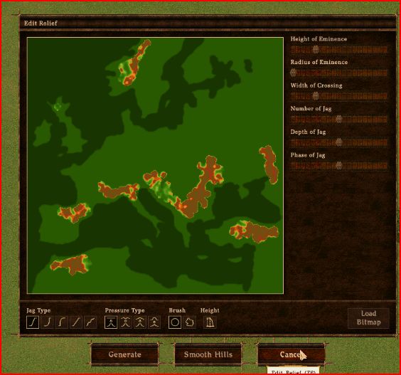
You can make use of one more handy instrument for relief editing by clicking on the button. A screen showing the altitude map of the area (green - lowlands, yellow-brown - hills, brown-grey - mountains) will pop up on the screen. A set of scrollbars allows you to regulate the parameters of the elevations generated: